Skip to content

What’s New for Quick Terrain Modeler Version 8.4.0

Applied Imagery is pleased to announce the release of QT Modeler v8.4.0, which solves one of our users’ biggest problems:  access to geospatial data.  Our revolutionary new QT Data Explorer enables intuitive, fast, and interactive searching and downloading from online data repositories – or your own data.  QTM v8.4.0 also includes layer tree export to KMZ (Google Earth), upgrades to our HLZ tool, the ability to create your own stencils, search tool upgrades, a new hillshade lighting tool, and much more!  Download Release Notes

QT Data Explorer

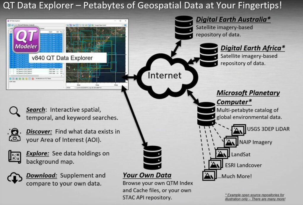
QT Data Explorer revolutionizes the search for online geospatial data by delivering a simple, yet powerful tool to interact with STAC API data repositories. Simply connect to a STAC API repository (e.g., Microsoft Planetary Computer), draw an Area of Interest on an interactive map, then start exploring the data that is available. You can discover unlimited types of data – LiDAR point clouds/DSM’s, color imagery, vectors, Landsat imagery, etc., sift through it, then download what you need, load it into QTM, and start working with it!

Export Layer Tree to KMZ

QTM’s new export layer tree to KMZ function exports all layer tree content into a single KMZ file that can be opened in Google Earth – or any software that can read KMZ. This can condense work that you’ve done in QTM (markers, routes, annotations, bookmarks, stencils) in a very compact format. Note: 3D data and textures are not included in this KMZ export, but can be exported independently in many formats.

Multidirectional Hillshade

QT Modeler’s Multi Directional Hillshade enables the activating and setting of, three additional lighting sources to the main directional lighting. This allows for a fuller shading component to the visualization of your surface model data.

Annotation Upgrades – Make Your Own Stencils

Stencils can now remember and honor color values, and you can create your own! Simply right click on any vector, Export > Save as Stencil. Then select that stencil whenever you need it in the future. This will make it much faster to create and reuse common vectors such as multi-color range rings.

Helicopter Landing Zone (HLZ)

We have added the number one requested HLZ upgrade: the ability to save/reload HLZ Presets. The HLZ upgrade in QTM v832 provided many more user settings, so users wanted an easy way to remember and reload those settings. There are several buttons at the top of the HLZ tool to facilitate this. In addition, HLZ now automatically creates a new Vertex Color layer every time the analysis is run (rather than overwriting).

Terrain X

Terrain-X, the tool that is used to mark local slopes and headings (very useful in annotating an HLZ), has gotten a cosmetic refresh. The lines and arrowheads are thicker, labels have caption offsets, and the primary arrow now will always point “downslope”.

Model Search

Model Search now has a few more search parameters and capabilities:

  • Inverse search (everything *outside* search area)
  • Search Quadrants (search NE, SE, SW, or NW quadrants individually if desired)
  • Added context menu option to remove items from list